Valparai
Valparai is a Taluk and hill station in Coimbatore district of Tamil Nadu,India. It is located 3,500 feet above sea level on the Anaimalai Hills range of the Western Ghats, at a distance of 100 km from Coimbatore and 65 km from Pollachi.There are 40 hairpin bends
on the way to Valparai from Azhiyar. While major portions of the land
is owned by private tea companies, large forest areas continue to be out
of bounds.
Valparai is a mid-elevation hill station (Ootacamund is considerably higher). The tea plantations are surrounded by evergreen forest. The region is also a rich elephant tract and is known to have many leopards
The scenic drive to the town from Pollachi passes through the Indira Gandhi Wild Life Sanctuary noted for elephants, boars, lion-tailed macaques, gaur, spotted deer, sambar, and Giant Squirrels. The area is also rich in birds, including the great hornbill.
Water bodies at Monkey falls and Aliyar Dam are also seen en route. A
famous place of worship, Balaji Temple also attracts pilgrims. Valparai
receives among the highest rainfall in the region during the monsoons


Solaiyar Dam:
Upper Solaiyar or Upper Sholayar Dam is situated 20 km (12 mi) from Valparai, a hill station in the Anaimalai Hills of the Coimbatore district, Tamil Nadu India. It is the second deepest dam in Asia.Template:Citation ≈needed A part of the hydroelectric project of Tamil Nadu, special permission is required to visit the dam.


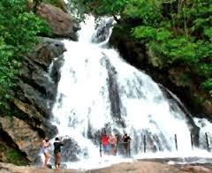
Monkey Falls:
Monkey Falls are natural waterfalls located near the uphill ghat road Valparai on the Pollachi-Valparai road in the Anaimalai Hills range, in Coimbatore district.
Monkey Falls is about 30 km from Pollachi. Refreshing Natural Water Falls about 6 km from Azhiyar Dam. Monkey Falls is located on road connecting Pollachi and Valparai.
Aliyar Reservoir
Aliyar Reservoir is a 6.48 km2 (2.5 sq mi) reservoir located near Pollachi town in Coimbatore District, Tamil Nadu, South India. The dam is located in the foothills of Valparai, in the Anamalai Hills of the Western Ghats.
Chinnakallar Falls
Chinnakallar Falls is the second highest rainfall area in the country.
This waterfall is located about 15 km away from Valparai and is
surrounded by dense forests.

Topslip:
Topslip is located at 800 feet (240 m) above sea level on the Anamalai mountain range. It is popularly known as Anamalai Hills. It is a small place in Indira Gandhi National Park and Wildlife Sanctuary that lies in the Coimbatore District of Tamil Nadu at the southern part of the Nilgiri Biosphere Reserve. Separated from the Nilgiri Hills by the Palghat Gap on the north, the Park is contiguous to the Parambikulam Wildlife Sanctuary (Kerala) to its west and to the Eravikulam National Park (Kerala) and Chinnar Wild life sanctuary.


The Anaimalai Hills :
The Anaimalai Hills is a range of mountains in the Western Ghats in Tamil Nadu and Kerala states of South India. The name "Anaimalai" derives from the Tamil/Malayalam word 'Anai' meaning elephant and 'Malai' meaning hill, thus Elephant Hill. The highest peak of the Anaimalai Hills is Anamudi, (2,695 meters (8,842 ft)), located in the Idukki district of Kerala. It is the highest peak in the Western ghats and South India. To the north, Palghat Gap divides the Western Ghats. The lower slopes of hills now have coffee and tea plantations as well as teak forests of great economic value.
No comments:
Post a Comment